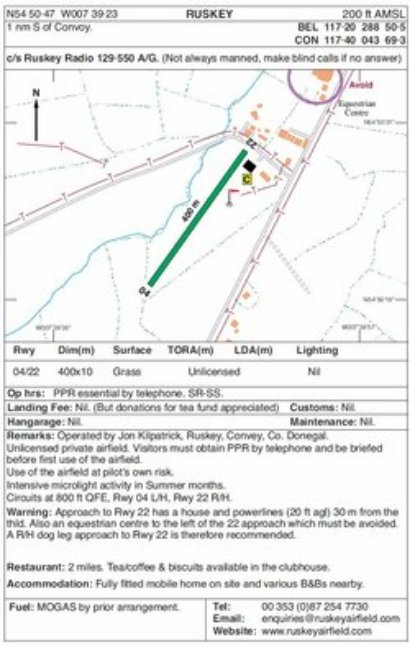
Airfield Information:
Co-Ordinates: N 54.50-473 W 007.39-226
Status: Unlicensed Private airfield, strictly PPR by telephone.
Insurance requirements: All pilots/aircraft must carry mandatory min insurance cover.
Elevation: 200 feet AMSL
Circuit Height: 800 feet QFE/1000 feet QNH
Runway orientation: 04 / 22
Runway Length: 400 metres x 10 metres
Circuit Pattern: 04 is L/H - 22 is R/H **see notes below**
Surface: Grass
Radio Freq: A/G 129.55 (Not always manned, make blind calls if no answer)
Operating Hours: SR / SS
Owner/Operator: Mr Jon Kilpatrick
PPR: By Telephone on +35387 2547730 **See notes below**
Landing Fee: Nil, but a donation to the tea/coffee fund is appreciated.
Fuel: Mogas only and by prior arrangement
Hangarage: Nil
Taxi: Yes
Hire Car: Yes
Accommodation: Fully fitted mobile home on site, B&B/Hotels nearby.
Amenities: Tea,Coffee & Biscuits in Clubhouse, toilets available.
NOTES:
Approach to 22 has houses & electrical wires 30 metres from the threshold, there is also an equestrian centre to the left of the 22 approach which we avoid, we therefore recommend a R/H dog-leg approach for 22, this is not an issue as there is lots of room.
We also insist that you are fully briefed before attempting to use the airfield for the first time.